Anexo:Regiones de Guyana
  |
|
Regiones de Guyana por número y nombre |
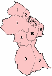
Guyana está dividida territorial y administrativamente en 10 regiones, a cada una de las cuales se asigna un número y un nombre:[1][2]
| N.º | Región | Bandera | Área (km²) |
Población (censo 2012) |
Población por km² |
Capital | Subdivisiones[3] | Código ISO 3166-2[4] |
|---|---|---|---|---|---|---|---|---|
| 1 | Barima-Guainí | 20 339 | 26 941 | 1.3 | Mabaruma |
|
GY-BA | |
| 2 | Pomerón-Supenaam | 6195 | 46 810 | 7.6 | Anna Regina |
|
GY-PM | |
| 3 | Islas Esequibo-Demerara Occidental | 3755 (*3) | 107 416 | 28.6 | Vreed en Hoop |
|
GY-ES | |
| 4 | Demerara-Mahaica | 2232 | 313 429 | 140.4 | Triumph[5][6] |
|
GY-DE | |
| 5 | Mahaica-Berbice | 4190 | 49 723 | 11.9 | Fort Wellington |
|
GY-MA | |
| 6 | Berbice Oriental-Corentyne | 36 234 | 109 431 | 3.0 | Nueva Ámsterdam |
|
GY-EB | |
| 7 | Cuyuní-Mazaruní | 47 213 | 20 280 | 0.4 | Bartica |
|
GY-CU | |
| 8 | Potaro-Siparuní | 20 051 | 10 190 | 0.5 | Mahdia |
|
GY-PT | |
| 9 | Alto Tacutu-Alto Esequibo | 57 750 | 24 212 | 0.4 | Lethem |
|
GY-UT | |
| 10 | Alto Demerara-Berbice | 17 040 | 39 452 | 2.3 | Linden |
|
GY-UD | |
| Guyana | 214 999 | 747 884 | 3.5 | Georgetown |
Cada región está administrada por un consejo regional democrático (Regional Democratic Council, RDC), que está encabezado por un presidente (chairman).[7] Las regiones de Guyana se dividen en tres tipos de consejos: consejos municipales o municipios (6), consejos democráticos vecinales (65) y consejos de villas amerindias (112),[8] además existen áreas no clasificadas (44) y una conservación.[9]
Divisiones históricas
editarNombres regionales anteriores:[10][11]
Regiones de Guyana (1971)
editar- East Berbice-Corentyne
- East Demerara-West Coast Berbice
- Mazaruni Potaro
- North West
- Rupununi
- West Demerara-Essequibo Coast
Regiones de la Guayana Británica (1958)
editar- East Berbice
- Essequibo
- Essequibo Islands
- North west (hinterlands)
- Mazaruni-Potaro (hinterlands)
- Rupununi (hinterlands)
Condados coloniales (antes de 1958)
editarReferencias
editar- ↑ Bureau of Statistics - Guyana (enlace roto disponible en este archivo)., CHAPTER III: POPULATION REDISTRIBUTION AND INTERNAL MIGRATION, Table 3.4: Population Density, Guyana: 1980 - 2002
- ↑ Guyana - Government Information Agency (enlace roto disponible en este archivo)., National Profile
- ↑ GADM. World / Guyana / sub-divisions
- ↑ Online Browsing Platform (OBP)
- ↑ «Region Four RDC office moves to Triumph». Stabroek News. Consultado el 18 de agosto de 2020.
- ↑ «Regional Democratic Council Region No. 4 - Demerara/Mahaica, Guyana». Regional Democratic Council Region No. 4via Facebook. Consultado el 18 de agosto de 2020.
- ↑ Government of Guyana, Statistics
- ↑ INDIGENOUS VILLAGES
- ↑ «Country Profile 2017-18 GUYANA». Commonwealth Local Government Forum. Consultado el 4 de septiembre de 2020.
- ↑ «Internal Administrative Divisions of British Guiana». Cia.gov. 29 de agosto de 1958. Archivado desde el original el 22 de enero de 2017. Consultado el 3 de enero de 2020.
- ↑ «ADMIN REGIONS DETAILED – GUYANA LANDS AND SURVEYS COMMISSION'S FACT PAGE ON GUYANA» (en inglés estadounidense). Consultado el 16 de marzo de 2021.