Archivo:Early Rus.png
Ver la imagen en su resolución original (922 × 609 píxeles; tamaño de archivo: 714 kB; tipo MIME: image/png)

|
Esta imagen debería volverse a crear como imágenes vectoriales SVG. Esto proporciona muchas ventajas, véase Commons:Media for cleanup (en inglés) para más información. Si ya hay una versión SVG de esta imagen disponible, por favor súbala a Commons. Tras subirla, reemplace esta plantilla con la plantilla
{{vector version available|nuevo nombre de imagen.svg}} en esta imagen. |

|
This map has been uploaded by Electionworld from en.wiki.x.io to enable the |
Resumen
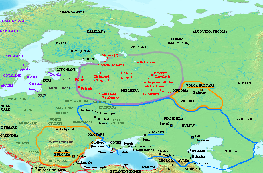
Map showing the distribution of early Varangian settlement, mid-ninth century CE. Varangian settlements shown in red, other Scandivanian settlement in purple. Grey names indicate locations of Slavic tribes. Blue outline indicates extent of Khazar sphere of influence.
Names in parenthesis indicate names of more familiar, and later, cities built on approximately the same site as the settlements named.
Note:There is controversy over the name of the original settlement at modern-day Rostov. Later Norse sources referred to the town (even in its earliest periods) as Rostofa or Ráðstofa. However, the original settlement (relevant to the period of this map) was at nearby Sarskoye Gorodishche, a later designation meaning simply "Citadel on the Sara River." The original name used by the town's Varangian inhabitants is unknown. For more information, see Rostov and Sarskoye Gorodishche.
Sources
- Christian, David. A History of Russia, Mongolia and Central Asia. Blackwell, 1999. ISBN 0631208143.
- Dolukhanov, P.M. The Early Slavs: Eastern Europe and the Initial Settlement to Kievan Rus'. London: Longman, 1996. ISBN 0582236185.
- Franklin, Simon and Jonathan Shepard. The Emergence of Rus 750-1200. London: Longman, 1996. ISBN 058249091X.
- Haywood, John. Cassell Atlas of World History.
- Pritsak, Omeljan. The Origin of Rus'. Cambridge Mass.: Harvard University Press, 1991.
Licencia

|
Se autoriza la copia, distribución y modificación de este documento bajo los términos de la licencia de documentación libre GNU, versión 1.2 o cualquier otra que posteriormente publique la Fundación para el Software Libre; sin secciones invariables, textos de portada, ni textos de contraportada. Se incluye una copia de la dicha licencia en la sección titulada Licencia de Documentación Libre GNU. |
| Este archivo se encuentra bajo la licencia Creative Commons Genérica de Atribución/Compartir-Igual 3.0. | ||
| ||
| Esta etiqueta de licencia fue agregada a este archivo como parte de la actualización de la licencia GFDL. |
Historial del archivo
Haz clic sobre una fecha y hora para ver el archivo tal como apareció en ese momento.
| Fecha y hora | Miniatura | Dimensiones | Usuario | Comentario | |
|---|---|---|---|---|---|
| actual | 07:30 26 jun 2023 | | 922 × 609 (714 kB) | Johannnes89 | Reverted to version as of 19:25, 21 May 2015 (UTC) crosswiki image spam, often containing historical inaccuracies |
| 00:07 26 jun 2023 |  | 922 × 609 (925 kB) | Valdazleifr | Update re-upload | |
| 00:03 26 jun 2023 |  | 922 × 609 (925 kB) | Valdazleifr | Updated the toponymy, fixing some errors in tribe placement during the period, now marked in red are the earliest Rus cities, those under the khaganate and those in gardariki, while Varangian controlled Finnic sttelments within gardariki are in black | |
| 19:25 21 may 2015 |  | 922 × 609 (714 kB) | Spiridon Ion Cepleanu | Cosmetic changes according with H.E.Stier (dir.) : Westermann Grosser Atlas zur Weltgeschichte, 1985, ISBN 3-14-100919-8 ; DTV Atlas zur Weltgeschichte, 1987 french version Perrin, ISBN 2-7242-3596-7 ; Putzger historischer Weltatlas Cornelsen 1990, ISB... | |
| 23:15 18 ene 2007 |  | 922 × 609 (742 kB) | Electionworld | {{ew|en|Briangotts}} == Summary == Map showing the distribution of early Varangian settlement, mid-ninth century CE. Varangian settlements shown in red, other Scandinavian settlement in purple. Grey names indicate locations of Slavic tribes. B |
Usos del archivo
Las siguientes páginas usan este archivo:
Uso global del archivo
Las wikis siguientes utilizan este archivo:
- Uso en af.wiki.x.io
- Uso en ba.wiki.x.io
- Uso en be-tarask.wiki.x.io
- Uso en bg.wiki.x.io
- Uso en ca.wiki.x.io
- Uso en ckb.wiki.x.io
- Uso en cs.wiki.x.io
- Uso en da.wiki.x.io
- Uso en de.wiki.x.io
- Uso en el.wiki.x.io
- Uso en en.wiki.x.io
- Uso en fa.wiki.x.io
- Uso en fi.wiki.x.io
- Uso en fr.wiki.x.io
- Uso en gl.wiki.x.io
- Uso en hy.wiki.x.io
- Uso en io.wiki.x.io
- Uso en is.wiki.x.io
- Uso en it.wiki.x.io
- Uso en ja.wiki.x.io
- Uso en ko.wiki.x.io
- Uso en lv.wiki.x.io
- Uso en pl.wiki.x.io
- Uso en pt.wiki.x.io
- Uso en ru.wiki.x.io
Ver más uso global de este archivo.