Archivo:Grand Central Railway route map 2010.svg

Tamaño de esta previsualización PNG del archivo SVG: 445 × 599 píxeles. Otras resoluciones: 178 × 240 píxeles · 356 × 480 píxeles · 570 × 768 píxeles · 761 × 1024 píxeles · 1521 × 2048 píxeles · 1000 × 1346 píxeles.
Ver la imagen en su resolución original ((Imagen SVG, nominalmente 1000 × 1346 pixels, tamaño de archivo: 1,61 MB))
Resumen
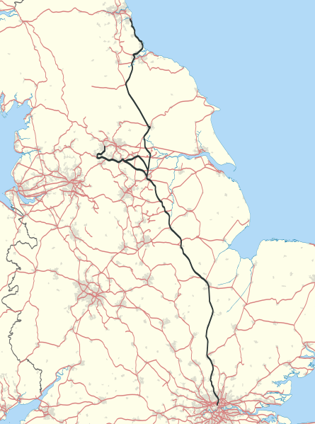
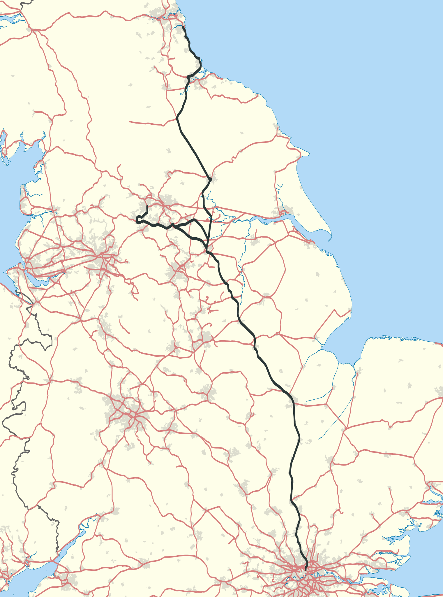
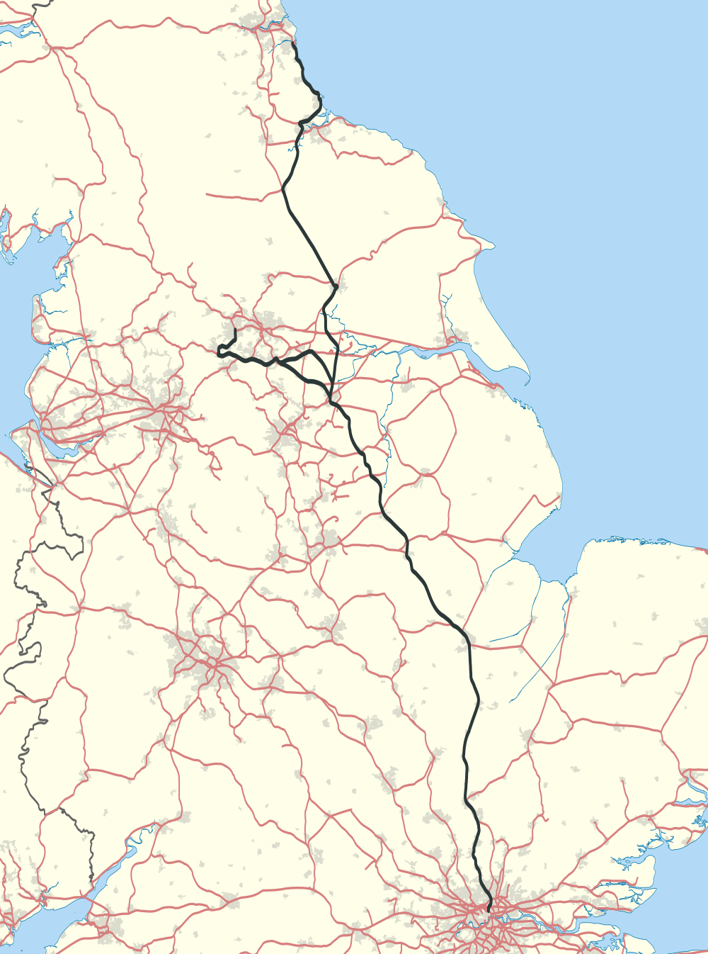
| Descripción | Map showing railway routes operated by the Grand Central Railway in 2010. The background map shows the coastline and major urban areas. Equirectangular map projection on WGS 84 datum, with N/S stretched 165% |
| Fecha | |
| Fuente |
|
| Autor | Nilfanion |
Licencia
Yo, titular de los derechos de autor de esta obra, la publico en los términos de las siguientes licencias:
Este archivo se encuentra bajo la licencia Creative Commons Genérica de Atribución/Compartir-Igual 3.0.
- Eres libre:
- de compartir – de copiar, distribuir y transmitir el trabajo
- de remezclar – de adaptar el trabajo
- Bajo las siguientes condiciones:
- atribución – Debes otorgar el crédito correspondiente, proporcionar un enlace a la licencia e indicar si realizaste algún cambio. Puedes hacerlo de cualquier manera razonable pero no de manera que sugiera que el licenciante te respalda a ti o al uso que hagas del trabajo.
- compartir igual – En caso de mezclar, transformar o modificar este trabajo, deberás distribuir el trabajo resultante bajo la misma licencia o una compatible como el original.

|
Se autoriza la copia, distribución y modificación de este documento bajo los términos de la licencia de documentación libre GNU, versión 1.2 o cualquier otra que posteriormente publique la Fundación para el Software Libre; sin secciones invariables, textos de portada, ni textos de contraportada. Se incluye una copia de la dicha licencia en la sección titulada Licencia de Documentación Libre GNU. |
Puedes usar la licencia que prefieras.
Historial del archivo
Haz clic sobre una fecha y hora para ver el archivo tal como apareció en ese momento.
| Fecha y hora | Miniatura | Dimensiones | Usuario | Comentario | |
|---|---|---|---|---|---|
| actual | 11:14 8 oct 2020 | | 1000 × 1346 (1,61 MB) | Cieran 91 | Previous map was heavily outdated, did not include split route on West Riding services - not all Grand Central services call at Pontefract Monkhill, diversion at Shaftholm Jct direct to Wakefield. |
| 23:03 1 feb 2011 |  | 1000 × 1346 (1,61 MB) | Nilfanion | {{Information |Description=Map showing railway routes operated by the Grand Central Railway in 2010. The background map shows the coastline and major urban areas. Equirectangular map projection on WGS 84 datum, with N/S stretch |
Usos del archivo
La siguiente página usa este archivo:
Uso global del archivo
Las wikis siguientes utilizan este archivo:
- Uso en en.wiki.x.io
- Uso en fr.wiki.x.io
- Uso en simple.wiki.x.io
- Uso en www.wikidata.org