Archivo:John-Tallis-1851-Tibet-Mongolia-and-Manchuria-NE.jpg

Tamaño de esta previsualización: 800 × 533 píxeles. Otras resoluciones: 320 × 213 píxeles · 640 × 427 píxeles · 1024 × 683 píxeles · 1280 × 853 píxeles · 2100 × 1400 píxeles.
Ver la imagen en su resolución original (2100 × 1400 píxeles; tamaño de archivo: 2,34 MB; tipo MIME: image/jpeg)
| Descripción |
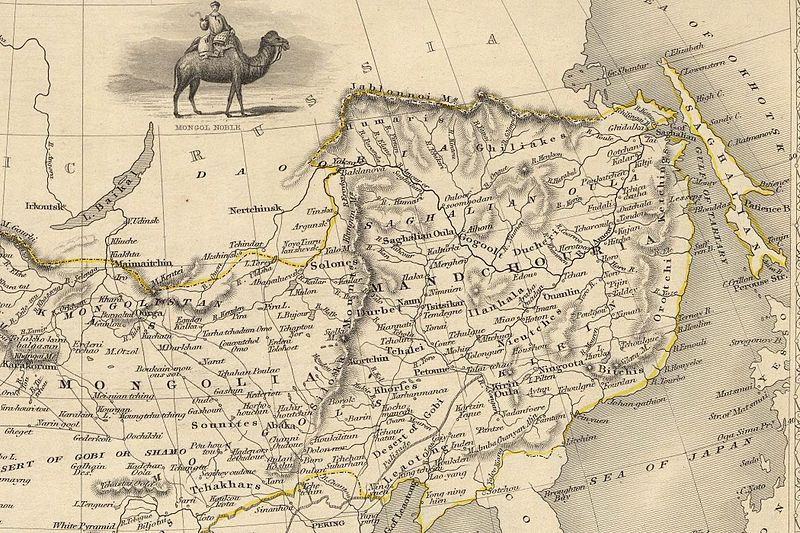
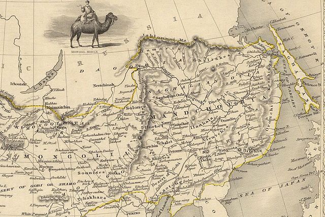
English: The NE section (Manchuria and Mongolia) of the map of the northern and western part of the Chinese Empire - "Thibet, Mongolia, and Mandchouria". The borders are shows as per the 1858 treaty of Aigun. The main Russian center in Transbaikalia is still Nerchinsk, rather than Chita. The outline of Sakhalin is already shown fairly correctly, but the body of water separating it from the mainland is still labeled "Gulf of Tartary" (rather than '"Strait). |
| Fecha | (UTC) |
| Fuente | |
| Autor |
|
| Otras versiones |
 |
| Esta es una imagen retocada, lo que significa que ha sido alterada digitalmente de su versión original. Modificaciones: NE section. La original se puede ver aquí: John-Tallis-1851-Tibet-Mongolia-and-Manchuria-33621.jpg. Las modificaciones las hizo Vmenkov.
|
|
Este material está en dominio público en los demás países donde el derecho de autor se extiende por 70 años (o menos) tras la muerte del autor. | |
| Esta obra ha sido identificada como libre de las restricciones conocidas en virtud del derecho de autor, incluyendo todos los derechos conexos. | |
Registro original de carga
This image is a derivative work of the following images:
- File:John-Tallis-1851-Tibet-Mongolia-and-Manchuria-33621.jpg licensed with PD-old
- 2009-12-07T02:26:08Z Vmenkov 4700x3750 (4267392 Bytes) better resolution, as available from http://www.davidrumsey.com/luna/servlet/detail/RUMSEY~8~1~821~60126:Thibet,-Mongolia,-and-Mandchouria--
- 2009-12-07T01:38:06Z Vmenkov 1289x989 (395245 Bytes) {{Information |Description={{en|1=Map of the northern and western part of the Chinese Empire - "Thibet, Mongolia, and Mandchouria".
Uploaded with derivativeFX
Historial del archivo
Haz clic sobre una fecha y hora para ver el archivo tal como apareció en ese momento.
| Fecha y hora | Miniatura | Dimensiones | Usuario | Comentario | |
|---|---|---|---|---|---|
| actual | 03:10 7 dic 2009 | | 2100 × 1400 (2,34 MB) | Vmenkov | {{Information |Description={{en|1=The NE section (Manchuria and Mongolia) of the map of the northern and western part of the Chinese Empire - "Thibet, Mongolia, and Mandchouria". The borders are shows as per the 1858 treaty of Aigun. The main Russian cent |
Usos del archivo
Las siguientes páginas usan este archivo:
Uso global del archivo
Las wikis siguientes utilizan este archivo:
- Uso en als.wiki.x.io
- Uso en ar.wiki.x.io
- Uso en bn.wiki.x.io
- Uso en ca.wiki.x.io
- Uso en cs.wiki.x.io
- Uso en cv.wiki.x.io
- Uso en da.wiki.x.io
- Uso en de.wiki.x.io
- Uso en en.wiki.x.io
- Uso en en.wiktionary.org
- Uso en eo.wiki.x.io
- Uso en fa.wiki.x.io
- Uso en fi.wiki.x.io
- Uso en fr.wiki.x.io
- Uso en hy.wiki.x.io
- Uso en id.wiki.x.io
- Uso en it.wiki.x.io
- Uso en ja.wiki.x.io
- Uso en ka.wiki.x.io
- Uso en kk.wiki.x.io
- Uso en ko.wiki.x.io
- Uso en la.wiki.x.io
- Uso en lt.wiki.x.io
- Uso en mn.wiki.x.io
- Uso en no.wiki.x.io
- Uso en pl.wiki.x.io
Ver más uso global de este archivo.