Archivo:Nanda-region-map-annotated.jpg
Nanda-region-map-annotated.jpg (621 × 597 píxeles; tamaño de archivo: 366 kB; tipo MIME: image/jpeg)
Historial del archivo
Haz clic sobre una fecha y hora para ver el archivo tal como apareció en ese momento.
| Fecha y hora | Miniatura | Dimensiones | Usuario | Comentario | |
|---|---|---|---|---|---|
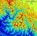
| actual | 22:18 3 may 2007 |  | 621 × 597 (366 kB) | Spireguy | {{Information |Description=Shaded contour map of the Nanda Devi region in Uttarakhand, India. Made with MATLAB using free SRTM data; labels done in Paint Shop Pro. Region shown is from Latitude 31N to 30N, Longitude 79.3E to 80.5E. |Source=self-made, usin |
| 22:05 3 may 2007 |  | 800 × 999 (382 kB) | Spireguy | {{Information |Description=Shaded contour map of the Nanda Devi region in Uttarakhand, India. Made with MATLAB using free SRTM data; labels done in Paint Shop Pro. Region shown is from Latitude 31N to 30N, Longitude 79.3E to 80.5E. |Source=self-made |Date |
Usos del archivo
La siguiente página usa este archivo:
Uso global del archivo
Las wikis siguientes utilizan este archivo:
- Uso en anp.wiki.x.io
- Uso en de.wiki.x.io
- Uso en el.wiki.x.io
- Uso en en.wiki.x.io
- Uso en hi.wiki.x.io
- Uso en hr.wiki.x.io
- Uso en hu.wiki.x.io
- Uso en pt.wiki.x.io
- Uso en sl.wiki.x.io
- Uso en sr.wiki.x.io
- Uso en sv.wiki.x.io
- Uso en te.wiki.x.io

