Archivo:Pyrenees topographic map-fr.svg

Ver la imagen en su resolución original ((Imagen SVG, nominalmente 3200 × 1900 pixels, tamaño de archivo: 6,38 MB))
![]()
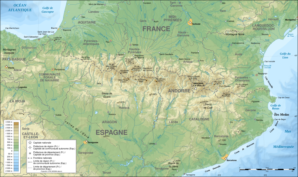
Detailed map of large dimension. For a better viewing, click on the link of the image above.
Carte détaillée de grande dimension. Pour une visualisation optimale, cliquer sur le lien de l'image ci-dessus.
Resumen
| Descripción |
English: Topographic map in French of the Pyrenees mountains.
Note: The shaded relief is a raster image embedded in the SVG file. Français : Carte topographique des Pyrénées en francais.
Note : Le relief ombré est une image bitmap embarquée dans le fichier SVG. Português: Mapa topográfico (em Francês) dos Pirenéus.
Español: Mapa topográfico (en francés) de los Pirineos.
UTM projection; WGS84 datum; shaded relief (composite image of N-W, W and N lightning positions);
|
||
| SVG desarrollo | |||
| Fecha | May 2007 (modified September 2008) | ||
| Fuente |
Own work;
|
||
| Creador | |||
| Permiso (Reutilización de este archivo) |
|
||
| Georeferencing | If inappropriate please set warp_status = skip to hide. | ||
| Otras versiones |
[]
|


Valoración
|

Esta imagen ha sido seleccionada como la Imagen del día el 1 de agosto de 2007. Fue descrita como sigue: Otros idiomas:
Čeština: Francouzská mapa pohoří Pyreneje Dansk: Topografisk kort over Pyrenæerne på fransk. English: Topographic map in French of the Pyrenees mountains. Français : Carte topographique des Pyrénées en français. Magyar: A Pireneusok térképe Nederlands: Franse Topografische kaart van de Pyreneeën Português: Um mapa topográfico em francês, da região dos Pireneus. Română: Hartă topografică a munților Pirinei, Franța. Suomi: Topografinen kartta Ranskasta, Pyreneiden vuorilta. Svenska: Topografisk karta över Pyrenéerna på franska. Русский: Топографическая карта Пиренеев. Українська: Топографічна карта Піренеїв 中文: 法语注释的比利牛斯山地形图 中文(繁體): 庇里牛斯山的法語地形圖 עברית : מפה טופוגרפית בצרפתית של הרי הפירינאים |
Licencia

|
Se autoriza la copia, distribución y modificación de este documento bajo los términos de la licencia de documentación libre GNU, versión 1.2 o cualquier otra que posteriormente publique la Fundación para el Software Libre; sin secciones invariables, textos de portada, ni textos de contraportada. Se incluye una copia de la dicha licencia en la sección titulada Licencia de Documentación Libre GNU. |
| Este archivo se encuentra bajo la licencia Creative Commons Genérica de Atribución/Compartir-Igual 3.0. | ||
| ||
| Esta etiqueta de licencia fue agregada a este archivo como parte de la actualización de la licencia GFDL. |
- Eres libre:
- de compartir – de copiar, distribuir y transmitir el trabajo
- de remezclar – de adaptar el trabajo
- Bajo las siguientes condiciones:
- atribución – Debes otorgar el crédito correspondiente, proporcionar un enlace a la licencia e indicar si realizaste algún cambio. Puedes hacerlo de cualquier manera razonable pero no de manera que sugiera que el licenciante te respalda a ti o al uso que hagas del trabajo.
- compartir igual – En caso de mezclar, transformar o modificar este trabajo, deberás distribuir el trabajo resultante bajo la misma licencia o una compatible como el original.
Historial del archivo
Haz clic sobre una fecha y hora para ver el archivo tal como apareció en ese momento.
| Fecha y hora | Miniatura | Dimensiones | Usuario | Comentario | |
|---|---|---|---|---|---|
| actual | 15:46 25 ene 2025 | | 3200 × 1900 (6,38 MB) | Iñaki LL | File uploaded using svgtranslate tool (https://svgtranslate.toolforge.org/). Added translation for eu. |
| 00:05 14 dic 2012 |  | 3200 × 1900 (6,3 MB) | Benh | uses Helvetica over Arial when available. | |
| 15:49 23 sep 2008 |  | 3200 × 1900 (6,3 MB) | Sting | Using ETOPO1 data for bathymetry; new standard colors | |
| 00:25 2 jul 2007 |  | 3200 × 1900 (5,9 MB) | Sting | + projection info in key ; + major cities areas ; some corrections in the rivers | |
| 20:30 25 jun 2007 |  | 3200 × 1900 (5,88 MB) | Sting | + key for borders | |
| 21:18 31 may 2007 |  | 3200 × 1900 (5,88 MB) | Sting | Some corrections | |
| 18:23 30 may 2007 |  | 3200 × 1900 (5,88 MB) | Sting | {{Information |Description=Topographic map in French of the Pyrenees mountains |Source=Own work ;<br/>Topographic map : [http://www2.jpl.nasa.gov/srtm NASA Shuttle Radar Topography Mission] (SRTM3 v.2) (public domain) edited with [http:// |
Usos del archivo
Las siguientes páginas usan este archivo:
Uso global del archivo
Las wikis siguientes utilizan este archivo:
- Uso en af.wiki.x.io
- Uso en an.wiki.x.io
- Uso en ar.wiki.x.io
- Uso en azb.wiki.x.io
- Uso en ba.wiki.x.io
- Uso en bs.wiki.x.io
- Uso en cs.wiki.x.io
- Uso en en.wiki.x.io
- Uso en eo.wiki.x.io
- Uso en et.wiki.x.io
- Uso en eu.wiki.x.io
- Uso en fa.wiki.x.io
- Uso en fi.wiki.x.io
- Uso en fr.wiki.x.io
- Ariège (département)
- Aude (département)
- Andorre
- Sentier de grande randonnée 10
- Haute-Garonne
- Hautes-Pyrénées
- Pyrénées-Atlantiques
- Pyrénées-Orientales
- Pyrénées
- Liste des communes des Hautes-Pyrénées
- Discussion:Liste des communes des Hautes-Pyrénées
- Pau
- Béarn
- Bayonne
- Tarbes
- Adour
- Ariège (rivière)
- Vals (Ariège)
- Catalogne
- Aragon (communauté autonome)
- Huesca
- Bizanos
- Pays basque
- Discussion:Béarn
- Discussion:Pau
- Val d'Aran
- Prades (Pyrénées-Orientales)
- Haute-Navarre
- Lugdunum Convenarum
- Lourdes
- Aranais
- Comminges
- Bethmale (fromage)
- Saint-Gaudens
Ver más uso global de este archivo.