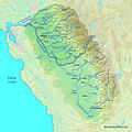
Archivo:SanJoaquinRiverMap.jpg

Tamaño de esta previsualización: 598 × 599 píxeles. Otras resoluciones: 240 × 240 píxeles · 479 × 480 píxeles · 767 × 768 píxeles · 1092 × 1094 píxeles.
Ver la imagen en su resolución original (1092 × 1094 píxeles; tamaño de archivo: 1,24 MB; tipo MIME: image/jpeg)
Historial del archivo
Haz clic sobre una fecha y hora para ver el archivo tal como apareció en ese momento.
| Fecha y hora | Miniatura | Dimensiones | Usuario | Comentario | |
|---|---|---|---|---|---|
| actual | 20:14 8 sep 2012 |  | 1092 × 1094 (1,24 MB) | Shannon1 | increased resolution and fixed some river courses in tulare basin |
| 04:31 31 ene 2011 |  | 917 × 753 (454 kB) | Shannon1 | updated, fixed some river paths, added location of dry lakes | |
| 18:56 30 ene 2010 |  | 1205 × 956 (623 kB) | Shannon1 | {{Information |Description={{en|1=Map of the San Joaquin River watershed, which drains most of central inland California into the Pacific}} |Source=Background from http://www2.demis.nl/mapserver/mapper.asp |Author=Background layer attributed to DEMIS Map |
Usos del archivo
La siguiente página usa este archivo:
Uso global del archivo
Las wikis siguientes utilizan este archivo:
- Uso en en.wiki.x.io
- Uso en hr.wiki.x.io
- Uso en id.wiki.x.io
- Uso en zh.wiki.x.io
