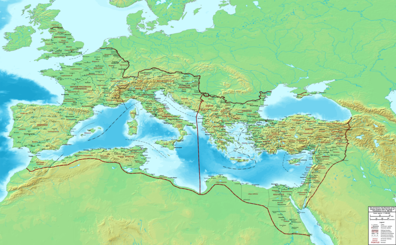
Archivo:The Roman Empire ca 400 AD.png

Tamaño de esta previsualización: 800 × 496 píxeles. Otras resoluciones: 320 × 198 píxeles · 640 × 397 píxeles · 1024 × 635 píxeles · 1280 × 793 píxeles · 2560 × 1587 píxeles · 4339 × 2689 píxeles.
Ver la imagen en su resolución original (4339 × 2689 píxeles; tamaño de archivo: 12,8 MB; tipo MIME: image/png)
Historial del archivo
Haz clic sobre una fecha y hora para ver el archivo tal como apareció en ese momento.
| Fecha y hora | Miniatura | Dimensiones | Usuario | Comentario | |
|---|---|---|---|---|---|
| actual | 22:27 19 feb 2015 |  | 4339 × 2689 (12,8 MB) | Cplakidas | added potential location of Valentia beyond Hadrian's Wall, removed provincial boundaries in Britannia as too tentative |
| 13:03 21 jul 2011 |  | 4339 × 2689 (10,9 MB) | Cplakidas | fixed Persian border, differentiated between Eastern and Western empire, different borders for praet. prefectures | |
| 02:37 21 mar 2009 |  | 4475 × 2600 (9,99 MB) | Cplakidas | minor corrections | |
| 12:30 29 may 2008 |  | 3800 × 2370 (8,1 MB) | Cplakidas | ||
| 12:17 29 may 2008 |  | 4560 × 2850 (11,22 MB) | Cplakidas | clearer version & addition of the Armenian satrapies | |
| 02:02 30 dic 2007 |  | 3380 × 2120 (5,96 MB) | Cplakidas | added names of dioceses, legend box, various minor adjustments | |
| 14:27 13 dic 2007 |  | 3550 × 2200 (6,65 MB) | Cplakidas | new improved version made with Inkscape, slight corrections in borders, added several cities in Africa & Spain | |
| 19:27 12 nov 2007 |  | 3550 × 2200 (4,75 MB) | Cplakidas | minor corrections in southern Gaul | |
| 12:58 5 nov 2007 |  | 3550 × 2200 (4,75 MB) | Cplakidas | New version, with some corrections & additions | |
| 16:55 31 oct 2007 |  | 3436 × 2142 (4,5 MB) | Cplakidas | {{Information |Description=Map of the Roman Empire ca. 400 AD, showing the administrative division into dioceses and provinces, as well as the major cities. The demarcation between Eastern and Western Empires is noted in red. |Source=Base map found at |
Usos del archivo
Las siguientes páginas usan este archivo:
Uso global del archivo
Las wikis siguientes utilizan este archivo:
- Uso en af.wiki.x.io
- Uso en ar.wiki.x.io
- Uso en ary.wiki.x.io
- Uso en ast.wiki.x.io
- Uso en bg.wiki.x.io
- Uso en bn.wiki.x.io
- Uso en ca.wiki.x.io
- Uso en ceb.wiki.x.io
- Uso en cs.wiki.x.io
- Uso en de.wiki.x.io
- Uso en el.wiki.x.io
- Uso en en.wiki.x.io
- Uso en eo.wiki.x.io
- Uso en et.wiki.x.io
- Uso en fr.wiki.x.io
- Uso en he.wiki.x.io
- Uso en hi.wiki.x.io
- Uso en hr.wiki.x.io
- Uso en hu.wiki.x.io
- Uso en id.wiki.x.io
- Uso en it.wiki.x.io
- Uso en ko.wiki.x.io
- Uso en la.wiki.x.io
Ver más uso global de este archivo.


