Archivo:Valle Central de Costa Rica.jpg
Ver la imagen en su resolución original (1152 × 870 píxeles; tamaño de archivo: 197 kB; tipo MIME: image/jpeg)
Resumen
| Descripción |
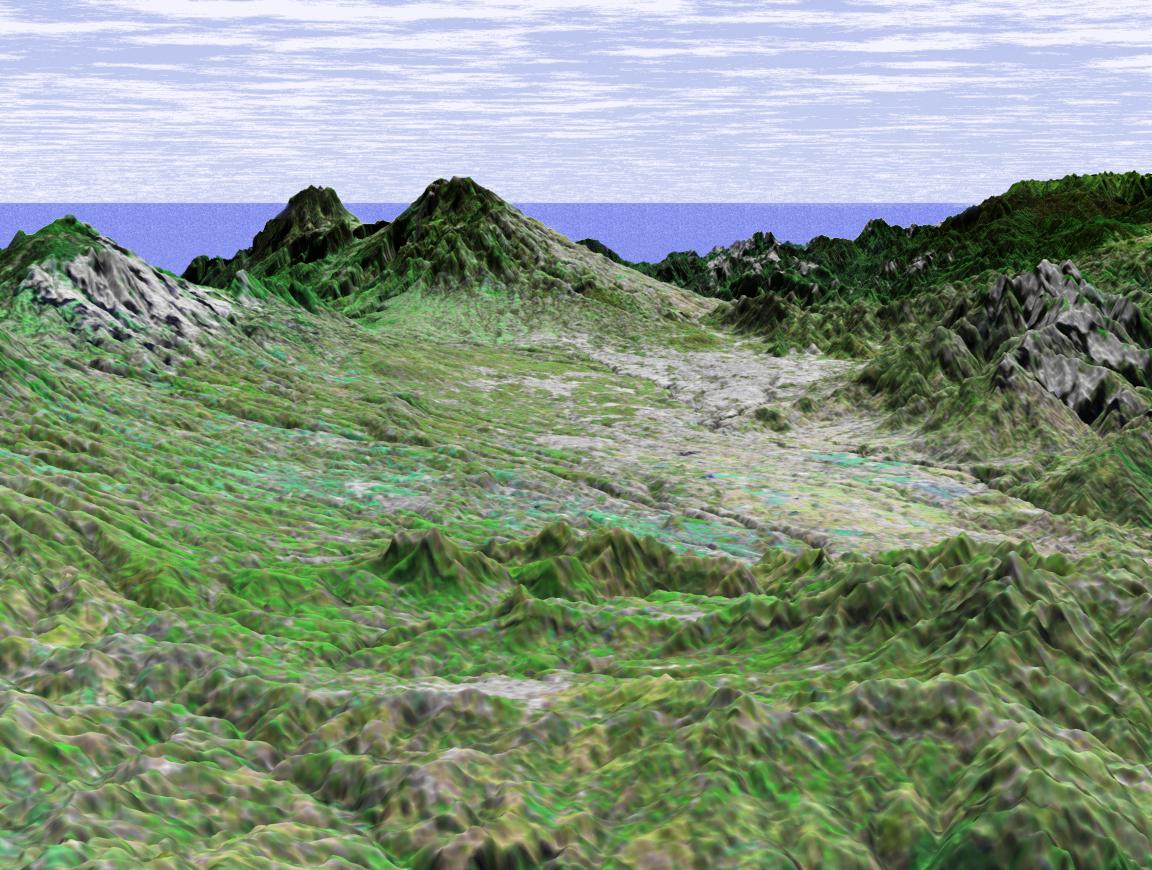
Español: Imagen de radar del Valle Central de Costa Rica grabada por la misión del transbordador espacial STS-99 de la NASA en 2000.
English: Radar image of the Central Valley of Costa Rica recorded by the NASA Space Shuttle mission STS-99 in 2000.
NASA image title: Shuttle Radar Topography Mission (SRTM) Perspective View with Landsat Overlay: San Jose, Costa Rica. NASA image description: This perspective view shows the capital city of San Jose, Costa Rica, in the right center of the image (gray area). Rising behind it are the volcanoes Irazu, 3402 meters high (11,161 feet) and Turrialba, 3330 meters high (10,925 feet.) Irazu is the highest volcano in Costa Rica and is located in the Irazu Volcano National Park, established in 1955. There have been at least 23 eruptions of Irazu since 1723, the most recent during 1963 to 1965. This activity sent tephra and secondary mudflows into cultivated areas, caused at least 40 deaths, and destroyed 400 houses and some factories. This image was generated in support of the Central American Commission for Environment and Development through an agreement with NASA. The Commission involves eight nations working to develop the Mesoamerican Biological Corridor, an effort to study and preserve some of the most biologically diverse regions of the planet. This three-dimensional perspective view was generated using topographic data from the Shuttle Radar Topography Mission (SRTM) and an enhanced false-color Landsat 7 satellite image. Colors are from Landsat bands 5, 4, and 2 as red, green and blue, respectively. Topographic expression is exaggerated 2X. Landsat has been providing visible and infrared views of the Earth since 1972. SRTM elevation data matches the 30-meter resolution of most Landsat images and will substantially help in analyses of the large and growing Landsat image archive. The Landsat 7 Thematic Mapper image used here was provided to the SRTM by the United States Geological Survey, Earth Resources Observation Systems (EROS) Data Center, Sioux Falls, South Dakota. Elevation data used in this image was acquired by the Shuttle Radar Topography Mission (SRTM) aboard the Space Shuttle Endeavour, launched on February 11, 2000. SRTM used the same radar instrument that comprised the Spaceborne Imaging Radar-C/X-Band Synthetic Aperture Radar (SIR-C/X-SAR) that flew twice on the Space Shuttle Endeavour in 1994. SRTM was designed to collect three-dimensional measurements of the Earth's surface. To collect the 3-D data, engineers added a 60-meter-long (200-foot) mast, installed additional C-band and X-band antennas, and improved tracking and navigation devices. The mission is a cooperative project between the National Aeronautics and Space Administration (NASA), the National Imagery and Mapping Agency (NIMA) of the U.S. Department of Defense (DoD), and the German and Italian space agencies. It is managed by NASA's Jet Propulsion Laboratory, Pasadena, CA, for NASA's Earth Science Enterprise,Washington, DC. Size: scale varies in this perspective image Location: 10.0 deg. North lat., 83.8 deg. East lon. Orientation: looking Southeast Image Data: Landsat Bands 5, 4, 3 as red, green, blue respectively Original Data Resolution: SRTM 30 meters (99 feet) Date Acquired: February, 2000 (SRTM) |
| Fecha | (date posted online) |
| Fuente | Shuttle Radar Topography Mission (SRTM) Perspective View with Landsat Overlay: San Jose, Costa Rica. |
| Autor | NASA/JPL/NIMA/USGS |
Este archivo fue catalogado por Johnson Space Center de la Administración Nacional de Aeronáutica y del Espacio (NASA) de los Estados Unidos de Américabajo el identificador de foto: PIA03316.Esta etiqueta no indica el estado de los derechos de autor del trabajo adjunto. Se requiere una etiqueta de derechos de autor normal. Para más información vea Commons:Sobre las licencias. Otros idiomas:
|
Licencia
| Este archivo es de dominio público porque fue creado por la NASA. Las políticas sobre copyright de la NASA estipulan que «el material de la NASA no está protegido con copyright a menos que se indique lo contrario». (Políticas sobre copyright de la NASA o Políticas sobre la utilización de imágenes del Jet Propulsion Laboratory). | ||
 |
Advertencias:
|
Historial del archivo
Haz clic sobre una fecha y hora para ver el archivo tal como apareció en ese momento.
| Fecha y hora | Miniatura | Dimensiones | Usuario | Comentario | |
|---|---|---|---|---|---|
| actual | 19:27 13 may 2021 | | 1152 × 870 (197 kB) | Spideog | Larger image, higher resolution |
| 03:43 25 sep 2005 |  | 600 × 453 (48 kB) | ArquiWHAT | Valle Central de Costa Rica tomado de http://visibleearth.nasa.gov/images/2045/PIA03316_md.jpg |
Usos del archivo
Las siguientes páginas usan este archivo:
Uso global del archivo
Las wikis siguientes utilizan este archivo:
- Uso en lld.wiki.x.io
- Uso en www.wikidata.org